

Vantor
Access the sharpest satellite imagery, Earth and geo-spatial intelligence with Vantor(formerly Maxar).
The Spatial Distillery Company is your Australian partner for Vantor satellite data, helping organisations across government, utilities, mining, and environmental sectors leverage Earth observation technology for critical decision-making.
Disclaimer: In October 2025, Maxar Intelligence officially re-branded as Vantor, marking its evolution from a satellite-imagery provider into a full-spectrum spatial-intelligence company.
-
The Vantor Hub
The Vantor Hub (formerly Maxar Geospatial Platform Pro or MGP Pro) gives you on-demand access to high-resolution satellite imagery, custom tasking, and extensive 2D and 3D basemap libraries. This cloud-based platform eliminates the complexity of working with satellite data.
-
Vivid
Vivid is Vantor's continuously updated global basemap product. Using AI-powered change detection, Vivid maintains an accurate spatial foundation that reflects real-world conditions – not outdated imagery from years ago.
This matters for Australian organisations tracking rapid urban development, infrastructure expansion, or environmental changes. Vivid ensures your basemap reflects current ground truth, improving decision accuracy across planning, asset management, and operational response.
-
World View
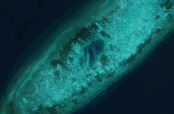
WorldView, backed by Vantor’s constellation, offers the most advanced commercial Earth observation satellites available. These spacecraft deliver imagery at a resolution of up to 30cm with industry-leading positional accuracy and rapid revisit times.
Vantor Hub offers:

Archive Access: Search and download from millions of square kilometres of existing imagery spanning over two decades.
Custom Tasking: Commission new satellite captures for your specific area of interest and timeframe.
3D Basemaps: Generate accurate terrain models for analysis and visualisation.
Streaming Services: Integrate satellite layers directly into your GIS workflows.
Analytics Tools: Perform change detection, feature extraction, and spatial analysis within the platform.
For Australian users managing infrastructure, monitoring environmental change, or planning major projects, Vantor Hub provides the imagery foundation your analysis requires.
The Spatial Distillery Company for Vantor Imagery: Why Work with Us?
We simplify access and application of Vantor satellite intelligence.. Our team is ready to help integrate high-resolution data into your workflow, offering expert, hands-on guidance with other platforms.
Build capability in-house with our GIS courses, including QGIS geocoding and onboarding support. We make it easy to get started with Vantor imagery, and even easier to scale.
Optical, SAR & 3D Vantor Technologies
Vantor imagery offers a complete suite of remote sensing tools to match every environment and application:
Optical Imagery: High-resolution colour and multispectral images for visual inspection, analysis, and change detection.
SAR (Synthetic Aperture Radar): See through clouds, smoke, or darkness with radar-based images. Ideal for defence, emergency response, and monitoring in poor conditions.
3D Surface Models: Generate lifelike, high-accuracy terrain data from satellite inputs. Perfect for urban modelling, line-of-sight analysis, and engineering.
Looking for a GIS software platform that works seamlessly with satellite data? Pair your Vantor satellite access with Global Mapper or contact our team for expert GIS consulting services.
Upgrade Your Next Project from a New Vantage Point
Vantor satellite imagery delivers the clarity, accuracy, and flexibility needed to drive innovation. The Spatial Distillery Company helps you unlock Vantor's full potential through planning and monitoring, emergency response, and 3D modelling.
Speak to our team about integrating satellite data into your projects.
Vantor FAQs
-
Vantor satellites collect new imagery daily. Through platforms like Vantor hub you can access collections as recent as the same day, as well as historical imagery dating back over two decades. For time-sensitive projects, custom tasking is also available.
-
WorldView satellites capture imagery at up to 30cm resolution – clear enough to identify individual vehicles, building features, and infrastructure assets. This level of detail supports detailed inspection, planning, and monitoring applications.
-
No minimums apply to archived imagery. For custom tasking, minimum area requirements may vary depending on the location and type of Vantor technologies used. We’ll help you find the most efficient option based on your project needs.
-
Vantor satellites collect new imagery daily across priority areas. Through Vantor Hub, you can access collections as recent as the same day, plus historical archives dating back over 20 years. Custom tasking is available for time-sensitive requirements.

“We are data distillers turning raw data into elegant location intelligence solutions.”
The Spatial Distillery Co.