

Home > Services > Consulting
GIS Consulting Services Australia
Practical GIS, spatial data and location intelligence expertise for organisations that need to make better decisions with location data.
Explore our Services
-
![Managed GIS services including GIS system management, patching, upgrades and ongoing support.]()
Managed GIS Services
Keep your GIS environment secure, current and reliable with proactive management and support.
-
![GIS Officer as a Service for flexible GIS expertise]()
GIS Officer as a Service
Extend your team with experienced GIS expertise without the cost of a full-time GIS specialist.
-
![GIS technical support for MapInfo, QGIS, FME, Vantor and other spatial technologies from The Spatial Distillery Co.]()
GIS Technical Support
Access experienced expert GIS support when you need it, from people who know the technology inside out
-
![Practical GIS training and capability development from The Spatial Distillery Co.]()
GIS Training & Capability
Build the GIS skills and confidence your team needs to get more from its spatial technology.
-
![Spatial analytics and location intelligence services from The Spatial Distillery Co.]()
Spatial Analytics
We transform location data into insights that reveal patterns, opportunities and risks.
-
![GeoAI and location intelligence for smarter spatial decisions]()
GeoAI & Spatial AI
Combine location intelligence with AI to discover insights and automate smarter spatial decisions.
-
![GIS software implementation, configuration and technical support from The Spatial Distillery Co.]()
GIS Software & Platforms
Get the right GIS technology, configured and supported to work for your organisation.
-
![Custom GIS applications, mapping solutions and spatial software development.]()
Custom GIS Development
Build spatial applications and tools designed around the way your organisation actually works.
-
![GIS workflow and spatial data automation services from The Spatial Distillery Co.]()
GIS Automation
Automate repetitive spatial workflows to save time, reduce errors and deliver data faster.
-
![Spatial data management, integration, quality and governance services from The Spatial Distillery Co.]()
Spatial Data Management
Build trusted, connected spatial data that your organisation can rely on.
-
![GIS integration with business systems, databases and enterprise applications.]()
GIS Integration
Connect GIS with the systems, data and workflows your organisation already uses.
-
![GIS strategy and spatial technology consulting from The Spatial Distillery Co.]()
GIS Strategy
Turn your spatial capabilities into a clear, practical roadmap for better decisions and better outcomes.











GIS Integration
Connect GIS with the systems, data and workflows your organisation already uses.
GIS delivers greater value when location information is connected to the rest of your organisation. The Spatial Distillery Co. provides GIS integration services that connect geographic information systems with business applications, databases, APIs and enterprise platforms. We can integrate GIS with systems used for asset management, property and rates, planning, customer management, finance, field operations, document management and other business processes. Our GIS integration capabilities include APIs, web services, spatial databases, ETL, data synchronisation and automated workflows. We work across desktop, web, enterprise and cloud GIS environments and can integrate existing technology without requiring organisations to replace systems unnecessarily. For councils and larger organisations, effective GIS integration can reduce duplicate data entry, improve data consistency and make location information available wherever it is needed.
We connect GIS to your business systems so spatial information becomes part of everyday operations rather than an isolated specialist capability.

GeoAI & Spatial AI
Combine location intelligence with AI to discover insights and automate smarter spatial decisions.
GeoAI brings artificial intelligence and geospatial technology together to create new ways of understanding location. The Spatial Distillery Co. helps organisations explore and implement practical applications of GeoAI, Spatial AI and machine learning across GIS and spatial data workflows. Applications can include extracting features from aerial and satellite imagery, classifying geographic information, identifying spatial patterns, automating data interpretation, searching spatial datasets using natural language and building AI-assisted spatial decision tools. We also explore how AI agents can interact with approved spatial datasets and GIS workflows to help users access information and perform spatial tasks more efficiently. Our approach is focused on solving real business problems rather than applying AI simply because it is new technology. We consider your data, GIS environment, security requirements, workflows and desired outcomes when determining where AI can deliver genuine value.
By combining geospatial expertise, spatial data and artificial intelligence, The Spatial Distillery Co. helps organisations move towards smarter, more automated and more accessible GIS.

Spatial Data Management
Build trusted, connected spatial data that your organisation can rely on
Reliable GIS depends on reliable spatial data. The Spatial Distillery Co. helps organisations source, manage, integrate, transform, maintain and improve geographic information. Our spatial data services cover the complete data lifecycle, including data acquisition, migration, cleansing, validation, transformation, quality assurance, spatial databases, data integration and ongoing maintenance. We work with a wide range of geospatial data including aerial imagery, satellite imagery, LiDAR, property and cadastral data, environmental information, infrastructure and asset data, demographic datasets and government datasets. We can establish spatial data standards and governance, improve data quality and develop repeatable processes for keeping information current. We also help organisations connect spatial datasets with enterprise systems so that GIS data is accessible to the people and applications that need it. Whether you need to clean up an existing spatial database, migrate GIS data, establish a new data architecture or build automated data pipelines.
The Spatial Distillery Co. helps turn complex spatial information into trusted, usable and maintainable business data.

Spatial Analytics
Transform location data into insights that reveal patterns, opportunities and risks.
Spatial analytics turns geographic data into evidence for better decisions. The Spatial Distillery Co. uses GIS, spatial analysis, location intelligence, imagery and other geographic datasets to identify patterns, relationships, trends, opportunities and risks. Our spatial analytics services can support questions relating to population, customers, assets, infrastructure, land use, development, accessibility, environment, vegetation, urban heat, service coverage and investment priorities. We combine multiple spatial datasets to provide a more complete understanding of what is happening, where it is happening and why location matters. Our team can undertake analysis at property, site, suburb, local government, regional and national scales, depending on the problem being solved. We can also develop repeatable analytical workflows and models so that analysis can be updated as new data becomes available.
From location intelligence and suitability analysis through to environmental modelling, demographic analysis and spatial decision support, The Spatial Distillery Co. transforms complex geographic information into clear, actionable insights.

Custom GIS Development
Build spatial applications and tools designed around the way your organisation actually works.
When standard GIS software cannot quite solve the problem, a custom spatial solution can. The Spatial Distillery Co. designs and develops bespoke GIS applications, web mapping solutions, spatial tools, dashboards, APIs and automated workflows around specific organisational requirements. We can build solutions for internal teams, field staff, customers, stakeholders or public-facing applications. Custom GIS development can include interactive mapping, spatial search, data visualisation, reporting, workflow automation, system integration and specialised spatial analysis. We begin with the business requirement rather than assuming a particular technology or platform. Where existing GIS software can provide the required functionality, we use it; where a bespoke solution provides a genuine advantage, we design and build the appropriate application. Our development expertise can also connect custom applications to existing GIS platforms, spatial databases and enterprise systems.
The result is practical spatial software that fits the way your organisation works, rather than forcing your workflows to fit a generic product.
GIS Automation
Automate repetitive spatial workflows to save time, reduce errors and deliver data faster.
Automating GIS workflows saves time, reduces errors and allows spatial teams to focus on higher-value work. The Spatial Distillery Co. designs and implements automated GIS and spatial data workflows that remove repetitive manual processes. We can automate data imports and exports, spatial ETL, data transformation, validation, quality assurance, GIS updates, imagery processing, reporting, map production and system-to-system data transfers. Automation is particularly valuable where teams repeatedly perform the same GIS process, update large datasets or need to produce consistent outputs on a regular schedule. We analyse existing workflows to identify unnecessary manual steps and then design reliable, repeatable processes using appropriate GIS and data technologies. Automated workflows can also improve data consistency, reduce human error and make important spatial processes easier to monitor and maintain.
From a simple repetitive GIS task to a complex enterprise data workflow, The Spatial Distillery Co. helps organisations use automation to make GIS faster, more consistent and more scalable.

GIS Software & Platforms
Get the right GIS technology, configured and supported to work for your organisation.
Choosing the right GIS software is only the beginning. The real value comes from implementing, configuring and supporting it properly. The Spatial Distillery Co. provides GIS software and platform services across desktop, enterprise, web, mobile and cloud environments. We have practical expertise across technologies including MapInfo Pro, QGIS, FME, Vantor and other spatial platforms, helping organisations select, implement, configure and optimise technology around their requirements. Our services can include software evaluation, architecture, installation, configuration, licensing, migration, upgrades, troubleshooting and technical support. We understand that GIS software needs to work for different users, from GIS professionals and data specialists through to planners, field staff, analysts and decision-makers. Our independent experience allows us to help organisations get more from their existing technology while identifying when a different platform or approach may provide a better result.
The Spatial Distillery Co. combines GIS consulting with hands-on software expertise to help organisations get maximum value from their spatial technology investment.

GIS Training & Capability
Build the GIS skills and confidence your team needs to get more from its spatial technology.
Effective GIS depends on capable people. The Spatial Distillery Co. provides practical GIS training designed to build the skills, confidence and capability organisations need to get more from their spatial technology. We deliver training across a range of GIS technologies and skill levels, including QGIS, MapInfo Pro, Global Mapper and other spatial tools, from foundational GIS concepts through to advanced workflows and spatial analysis. Training can be delivered as structured courses, tailored workshops or organisation-specific sessions based around your systems, datasets and business requirements. Our instructors bring practical industry experience, so training focuses on how GIS is actually used to solve problems rather than simply demonstrating software features. We can also help organisations develop broader GIS capability through knowledge transfer, workflow improvement and practical guidance.
Whether you are introducing GIS to new users, developing an experienced spatial team or improving organisational capability, The Spatial Distillery Co. provides training that connects GIS technology with real-world outcomes.

GIS Technical Support
Expert GIS support when you need it, from people who know the technology inside out.
When you are stuck with GIS software, data or licensing, get direct access to people who understand the problem. The Spatial Distillery Co. provides expert technical support for the GIS technologies and spatial products we supply and support. Our consultants have deep practical knowledge of MapInfo Pro, QGIS, FME, Vantor and other GIS technologies, allowing us to troubleshoot software issues, data problems, configuration errors, licensing challenges and other technical hurdles. Support is easily accessible by email and phone, giving you direct access to experienced GIS professionals rather than relying solely on generic helpdesk responses. We understand how frustrating it can be when a GIS problem stops you from getting your work done, so we pride ourselves on responding quickly and helping you find a practical solution. Support can cover software installation and configuration, licensing, troubleshooting, data issues, workflows and general technical questions relating to the products and services we provide.
When you hit a frustrating GIS hurdle, The Spatial Distillery Co. is here to help you get moving again—ASAP.

GIS Officer as a Service
Extend your team with experienced GIS expertise without the cost of a full-time GIS specialist.
The Spatial Distillery Co.'s GIS Officer as a Service provides flexible access to experienced GIS professionals who can become an extension of your organisation or team. This service is particularly valuable for councils, government organisations and businesses that need ongoing GIS capability but do not have the workload, budget or need for a permanent GIS Officer. Our GIS professionals can support day-to-day GIS operations, spatial data management, mapping, spatial analysis, reporting, GIS administration, project delivery and stakeholder requests. We can provide regular dedicated support or flexible capacity around specific requirements. Unlike project-based GIS consulting, GIS Officer as a Service is designed to provide ongoing operational capability and continuity. Your GIS Officer becomes familiar with your organisation, systems, data and priorities and can contribute as part of your team.
It is a practical way to access experienced GIS expertise when you need more capability without taking on another permanent employee.

Managed GIS Services
Keep your GIS environment current, secure and reliable while we take care of the technology behind it.
GIS platforms require ongoing management to remain secure, supported and reliable. The Spatial Distillery Co. provides managed GIS services for organisations that need specialist expertise to maintain their GIS deployments without managing everything internally. Our managed services can include software patching, upgrades, configuration, system maintenance, monitoring and technical support for GIS environments. We help organisations plan and manage updates so that software remains supported and security and maintenance requirements are addressed before they become operational problems. This is particularly valuable for enterprise GIS environments where GIS software, servers, databases and web services need to work together reliably. Rather than responding only when something breaks, our managed GIS approach is proactive and planned. We work with your organisation to understand the environment, establish appropriate maintenance processes and provide ongoing specialist support.
The result is a better-maintained GIS environment and greater confidence that your spatial systems will remain available, supported and fit for purpose.

GIS Strategy
Turn your spatial capabilities into a clear, practical roadmap for better decisions and better outcomes
A GIS strategy provides the foundation for a successful spatial capability. The Spatial Distillery Co. helps organisations develop practical GIS strategies that align spatial technology, data, people and business objectives. We assess your existing GIS environment, systems, data, workflows and organisational capability to identify gaps, opportunities and priorities. Our GIS consulting can cover enterprise GIS architecture, spatial data governance, GIS technology selection, platform strategy, integration, cloud and on-premise environments, licensing, security, skills and future capability. We work with local government, government agencies and organisations that rely on geographic information to support planning, operations and decision-making. Whether you are modernising an existing GIS, moving to a new platform, improving spatial data management or developing an enterprise GIS roadmap, we provide an independent and practical approach.
Our goal is to turn GIS from a collection of tools and datasets into a well-managed business capability that delivers measurable value.
GDA2020 Data
Make your spatial data more accurate, consistent and ready for the future.
The Spatial Distillery Co. helps organisations manage, improve and migrate their spatial data, including the transition from legacy datums to GDA2020. We work with councils, government agencies and businesses to assess existing spatial datasets, identify transformation requirements and develop practical migration strategies that minimise disruption to GIS operations.
Our spatial data services include data cleansing, validation, transformation, quality assurance, spatial database management and GDA2020 datum migration. We can assess datasets across your GIS environment, identify data that requires transformation and ensure spatial information is correctly aligned with your target coordinate reference system.
For organisations undertaking a GDA2020 migration, we can help determine which datasets, GIS applications, integrations and workflows need to be updated, as well as develop repeatable processes for transforming and validating data. We understand that datum migration is not simply a matter of converting coordinates—it can affect spatial databases, map layers, web services, analysis, integrations and downstream business processes.
Whether you need help managing your spatial data or are planning a migration to GDA2020, The Spatial Distillery Co. provides the GIS expertise and practical support to make the process accurate, controlled and manageable.
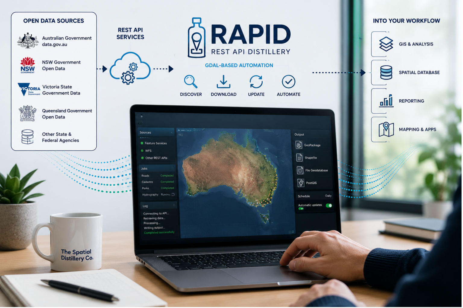
RAPID – REST API Distillery
Automate the retrieval of spatial data from open REST APIs and make government data easier to use.
RAPID (REST API Distillery) is a GDAL-based spatial data automation tool developed by The Spatial Distillery Co. to simplify the process of discovering, downloading and updating geographic data from open REST APIs. It is particularly useful for organisations that regularly work with Esri Feature Services and other common geospatial REST APIs.
RAPID helps organisations take advantage of the growing range of open spatial data published by Australian government agencies. Instead of manually downloading datasets, navigating web portals or repeatedly exporting data, RAPID can automate the retrieval of spatial information directly from supported REST services.
The tool can be used to access and incorporate open data from Australian state and federal government organisations, helping GIS teams bring authoritative datasets into their existing spatial data workflows. This can support applications such as planning, asset management, environmental analysis, mapping, reporting and spatial analytics.
Built around GDAL (Geospatial Data Abstraction Library), RAPID provides a practical way to incorporate API-based spatial data into repeatable GIS and data management processes. It can help reduce manual data handling, improve consistency and make it easier to keep datasets up to date.
RAPID turns complex REST API data retrieval into a repeatable spatial data workflow, helping organisations get more value from Australia's extensive open government data resources.

Why Work with a GIS Consultant?
A GIS consultant helps bridge the gap between your spatial data and real-world decisions. The right advice can help you:
Build or refine a GIS strategy.
Maximise return on GIS software investment.
Improve data accuracy and usability.
Automate manual processes and reporting.
Support internal teams with ongoing training.
Our GIS consulting is grounded in hands-on experience with GIS mapping software, a tailored approach to data standards and the tools your teams already use.

GIS Consulting Services: Who We Help
Practical GIS expertise for organisations that rely on location, data and spatial technology to make better decisions.
The Spatial Distillery Co. provides GIS consulting and spatial technology services to local government, government agencies, utilities, infrastructure providers and private industry across Australia. We help organisations get more value from their GIS by connecting the right people, spatial data, software, systems and workflows.
Our approach is practical and technology agnostic. We work with the GIS environment you already have—whether that includes MapInfo Pro, QGIS, FME, enterprise GIS, web mapping, spatial databases, satellite imagery or other geospatial technologies—and help you improve, integrate, automate or modernise it.
Our GIS consultants work across the full spatial technology lifecycle, from GIS strategy and spatial data management through to integration, spatial analytics, automation, custom development, GeoAI, training, technical support and managed GIS services.
We support organisations including:
Local government and councils — improving enterprise GIS capability, modernising spatial workflows, managing spatial data, supporting LGEP programs and maintaining GIS platforms and services.
Government agencies and public sector organisations — developing GIS strategies, integrating spatial information, automating data workflows and delivering reliable location-based information for operational and strategic decision-making.
Planning, development and transport organisations — combining spatial data, mapping, analytics and automation to support planning, infrastructure, transport and land-use decisions.
Environmental and sustainability organisations — using GIS, satellite imagery, spatial analytics and environmental data to understand vegetation, urban heat, land use, natural assets and environmental change.
Utilities and infrastructure providers — improving spatial data accuracy, asset information, field workflows, system integration and the management of large and complex geographic datasets.
Resources, mining and exploration organisations — using high-resolution satellite imagery, GIS, spatial data and location intelligence to support exploration, environmental assessment, planning and operational decision-making.
Private businesses — applying GIS and spatial analytics to asset management, property, site selection, customer analysis, network planning, operations and business intelligence.
Organisations that need additional GIS capability — accessing experienced GIS professionals through GIS Officer as a Service, technical support, training and managed GIS services without having to build every capability internally.
Whatever your industry, our focus is the same: make GIS more useful, more efficient and easier to manage—so your organisation can get more value from its spatial data and technology.

Let’s Talk About Your Project
The Spatial Distillery Company provides practical GIS consulting services to cut through the complexity and give your team clarity with spatial tools and workflows. From strategic reviews to hands-on training and support, we help you unlock the potential of location data.
Speak to a GIS consultant today. Let’s find the right solution together.
GIS Consultants with Experience You Can Rely On
We understand that every organisation has different structures, tools and timelines, offering GIS consulting with flexible delivery. You’ll get practical, software-agnostic advice and support that fits your team.
We offer:
One-off GIS strategic reviews.
Ongoing support packages for councils and departments.
On-site or virtual workshops and project sessions.
Customised delivery aligned to your internal tools.
Training alongside consulting, such as our QGIS course.
Our GIS consultants bring years of technical expertise, hands-on industry experience, and practical problem-solving to every project. With multi-industry backgrounds, they help remove bottlenecks, automate spatial workflows, and reduce reliance on external support for long-term scalability.
GIS Consultant FAQs
-
Every GIS consulting project is tailored, but it usually starts with a discovery session to understand your challenges. From there, we might review your GIS strategy, map out process improvements, provide technical training, or assist with data migration. Projects can be one-off or ongoing, depending on your goals.
-
If you’re working with spatial data and facing slow processes, inconsistent results, or unclear mapping outputs, a GIS consultant can help. We often work with teams who know what they want to achieve but need expert guidance on how to get there, whether that’s improving data quality, setting up efficient tools, or training staff to use GIS software more effectively.
-
Yes. Our GIS consultants work with your existing systems and software to minimise disruption and avoid costly overhauls. We support integration with SQL Server, web GIS platforms, REST APIs, and cloud storage, helping you get more from the tools you already use while making spatial workflows easier and faster.
We’d love to work with you.
“We are data distillers turning raw data into elegant location intelligence solutions.”
The Spatial Distillery Co.